Measuring the earth by radio telescopes
Disaster prediction by observation of radio waves from space
Next generation radio telescopes for prediction of major earthquakes
TOYO Corporation installed the only next generation VLBI radio telescope in Japan (with a parabolic antenna 13.2 meters in diameter) at the Ishioka Geodetic Observation Station (Ishioka City, Ibaraki Prefecture) of the Geospatial Information Authority of Japan of the Ministry of Land, Infrastructure, Transport and Tourism. The main feature is that the position (longitude/latitude) where the radio telescope itself is installed can be measured with a millimeter-scale high precision. The Geospatial Information Authority of Japan determines the position of Japan on the earth using the VLBI technology. The obtained location information is the basic data to examine the state of the Japanese Archipelago and is provided to various organizations.
Quasars (cosmic objects of high luminosity and strong radio emission) that exist in space are observed by radio telescopes. With such celestial bodies as the reference points, it is possible to determine the positions of radio telescopes on the earth. This makes it possible to measure accurately the rotation speed of the earth and the inclination of the rotation axis which change daily, and fluctuations of the continental plates. The earth’s crust movement data is useful for predicting the occurrence of large earthquakes and volcanic eruption activities.
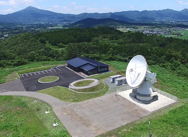
 Panoramic view of the Ishioka Geodetic Observation Station (the white parabolic antenna on the right is a radio telescope)
Source: Website of the Geospatial Information Authority of Japan
(https://www.gsi.go.jp/uchusokuchi/vlbi-igos.html)
The position on the earth can be measured with a millimeter-scale high precision through astronomical observation by radio telescopes
More than 20 countries participate in the project using the VLBI measurement technology. An increasing number of VLBI radio telescopes are being installed in various countries to enable worldwide observation. In Japan, the position and height of each observation station are determined with the radio telescope at Ishioka Geodetic Observation Station as the reference point. Because many years have passed since quasars emitted radio waves, the radio waves that reach the earth are of a very low level. Due to various radio waves that are used on the earth, it is very difficult to detect the radio waves from quasars. This is why a parabolic antenna 13.2 meters in diameter is required for the purpose.
Positioning accuracy was of a centimeter scale when measuring with a radio telescope of the previous technology, and it took a minimum of one week to determine the measured position. The next-generation radio telescope can determine the position with the positioning accuracy of a millimeter scale within 24 hours.
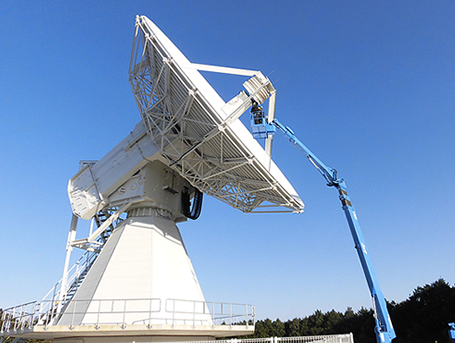
 Maintenance work on the VLBI radio telescope
(Ishioka Geodetic Observation Station)
 Quasar (evocative image)
Why is high-precision position data useful for disaster prevention?
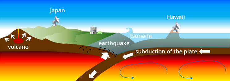
By observing the positions of the radio telescopes for a long time, various crustal movements that occur on a global scale can be captured. A typical example of such crustal movements is the continental plate movements. On the surface of the earth, about a dozen plates move on the mantle, which causes huge earthquakes and volcanic eruptions.
In 1985, the VLBI technology capable of measuring long distances accurately was used for the first time to measure plate movements. It was revealed that plates move at a speed of up to several centimeters per year. As an example of actual plate observation, the distance between the Island of Hawaii in the US and Japan is reduced by about 6 centimeters per year according to measurement data.
Precise measurements of changes in the earth’s crust and sea surface are expected to be useful in predicting disasters that occur on a global scale such as earthquakes, tsunamis, volcanic eruptions, sea level changes and floods, and in clarifying the mechanisms of earthquake occurrence, global warming and other phenomena.
 Schematic depiction of plate movements
Source: Website of the Geospatial Information Authority of Japan
(https://www.gsi.go.jp/uchusokuchi/vlbi-goal.html)
Big earthquakes may well occur anywhere in Japan. TOYO Corporation supports disaster prevention and recovery efforts through “measurement” technologies.


